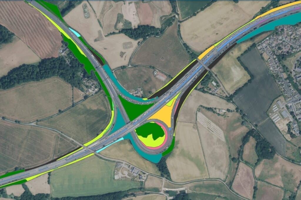
Investing in green mapping, the public body for highways in England is set to use artificial intelligence (AI) and satellite imagery to help track changes in habitats and biodiversity around transport routes.
Using the new state-of-the-art mapping tool will make it easier for National Highways to keep track of its Soft Estate ecosystems bordering the country’s 4,300 miles of motorways and major A-roads.
Over the last 10 to 15 years, routine inspection of the Soft Estate has provided a basic level of information. However, this needs to be improved if the government-owned company is to identify, manage and prioritise asset maintenance more efficiently, ultimately boosting biodiversity.
The project will help the company halt the decline of biodiversity across its activities by 2025, and support informed maintenance and renewal activities for the next Road Period (2025-2030).
Halting biodiversity decline by 2025
National Highways is the wholly government-owned company responsible for modernising, maintaining and operating England’s motorways and major A roads.
As one of the biggest landowners in the UK, it is also fast-becoming one of the country’s leading promoters and creators of natural habitats as it seeks to boost biodiversity.
In terms of sustainability goals, National Highways is on course to achieve its 2020 commitment of halting the decline of biodiversity and achieving no net loss in biodiversity across its activities by 2025.
Over the next five years, it will then make a further move towards becoming nature positive by delivering at least a 10% net gain in biodiversity on its Major Projects, whilst at the same time achieving a no net loss position across the Soft Estate as a whole between 2025 and 2030.
The gains are being delivered through enhancements built into the programme of Major Projects, biodiversity sustaining operational activities, and innovative partnerships with conservation charities.
Designated Funds for Environment and Wellbeing
Coinciding with the United Nations Biodiversity Day on 22 May, National Highways is marking Nature Week, highlighting the nature-focused work it and its partners do around the country.
Projects in the spotlight include:
- Transforming the site of a former open cast mine next to a major motorway upgrade on the M6 near Wigan into new wetlands, grassland and areas of woodland;
- Creating a linear pollinator network along the M65 and the M56 near Manchester;
- Creating wetlands to help clean river water near the M5 in Birmingham;
- A four-year project to introduce highland cows to the Nene Valley SSSI near Wellingborough;
- A 15-year agreement to support species-rich grasslands on Greena Moor Nature Reserve, in Cornwall;
- Helping bat populations to thrive on historic railway structures across the UK.
Many of these projects are being delivered by National Highways with help from its Designated Funds plans.
Designated Funds initiatives are separate to its core work of operating, maintaining and improving England’s strategic road network. They provide ring-fenced funding to invest in and support initiatives that deliver lasting benefits for road users, the environment and communities across England.
For its second road period from 2020 to 2025, National Highways will be investing £936M in Designated Funds across four main streams of interest and activity: Safety and Congestion; Environment and Wellbeing; Users and Communities; plus Innovation and Modernisation.
BNG, remote sensing and spatial analytics

Back in Oct 2023, the green mapping project completed a Concept Stage which explored whether answering the question of biodiversity net gain (BNG) was possible using remote sensing and spatial analytics.
Funded through the Designated Funds Innovation and Modernisation fund, the concept stage was conducted working alongside the Connected Places Catapult and Satellite Applications Catapult.
Overall, tech is a critical enabler, explains National Highways Senior Environmental Advisor Ben Hewlett:
“We’re excited to be working in this innovative area to ensure we’re improving our asset knowledge of the Soft Estate, maximising its biodiversity, and bringing long-lasting benefits to people, nature and wildlife. This is a glowing example of how new technologies such as AI can help to improve biodiversity at scale.“
Maintaining and even enhancing the quality of the environment is the aim, concludes Hewlett:
“We know roads have the potential to compromise the quality of their surrounding environments. For wildlife, roads can fragment important habitats, putting pressure on plant and animal populations.
“This project should help combat some of these challenges, by improving asset insight, identifying areas where we can increase biodiversity, putting nature at the heart of our network operation.”
Further Reading:
- More about National Highways in general; and its biodiversity work, in particular;
- More from National Highways on its four key investment plans for Designated Funds;
- More about the R&D work undertaken in 2022 with Manchester Metropolitan University;
- More on UK government planning practice around biodiversity net gain (BNG);
- More about UK innovation accelerators Connected Places Catapult and Satellite Applications Catapult;
- Also on SustMeme, Biodiversity risk not on business radar;
- Also on SustMeme, Microalgae bioreactors on track for carbon capture;
- Also on SustMeme, Conservation boost for endangered Tansy Beetle;
- Also on SustMeme, Ultra-early wildfire detection raises pilot-site alarm;
- Also on SustMeme, Space satellites launch to detect ‘dark ships’;
- Also on SustMeme, Half of humanity affected by land degradation;
- Also on SustMeme, Winners of the BIG Biodiversity Challenge Awards 2021.
Check out the full archive of stories under the SustMeme Biodiversity & Conservation topic.